When hiking in remote areas, dependable GPS devices with SOS and emergency messaging can be life-saving. This guide highlights top SOS-capable handheld GPS options, featuring satellite messengers, interactive SOS services, and rugged navigation performance. Each product section includes a concise overview, key sending capabilities, and how it supports remote locations with satellite connectivity.
| Product | Brand | Core SOS Feature | Connectivity |
|---|---|---|---|
| ZOLEO Satellite Communicator | ZOLEO | Emergency SOS Alerting | Iridium satellite, cellular, Wi-Fi |
| Garmin GPSMAP 67i | Garmin | Interactive SOS | InReach satellite technology |
| Garmin GPSMAP 67i (Renewed) | Garmin | Interactive SOS | InReach satellite technology |
| SPOT Gen 4 Satellite GPS Messenger | SPOT X | SOS button with GPS | Globalstar satellite network |
| ACR ResQLink 400 | ACR | GPS-enabled SOS alert | Satellite beacons (GPS) with no subscription |
Note: Each device serves different use cases—from map-heavy navigation to simple SOS-only signaling. When choosing, consider coverage needs, subscription or service requirements, device durability, battery life, and map availability for your typical hiking environments.
ZOLEO Satellite Communicator
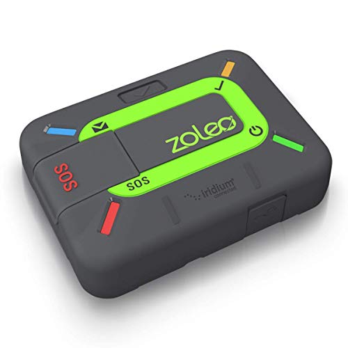
ZOLEO provides global satellite messaging that leverages the Iridium network while your smartphone remains the primary interface. It supports text messages and emails via satellite, cellular, or Wi-Fi using the most affordable available network (service plan required). In an emergency, an SOS alert sends your GPS location to a 24/7 monitoring center, with optional Medical Assist for non-emergency help. For extra security, you can add Field Rescue coverage from Global Rescue for immediate medical extraction if needed. This device is ideal for hikers who want smartphone-style messaging in areas beyond cell service.
Key features include satellite messaging with GPS location sharing, cross-network connectivity, and optional travel risk management coverage. Battery life varies by usage, and service plans are required for satellite access. While it excels at real-time messaging and alerting, users should ensure compatibility with their smartphone and understand the subscription requirements for ongoing satellite service. The device is compact, making it easy to carry during long treks and multi-day trips.
Useful considerations
- Check satellite coverage for your usual hiking regions (Iridium offers near-global coverage).
- Assess data needs: plain text vs. email and the potential costs of satellite messaging.
- Consider whether you want optional Global Rescue coverage for enhanced emergency support.
Garmin GPSMAP 67i Rugged GPS Handheld

The Garmin GPSMAP 67i integrates inReach satellite technology, delivering two-way messaging, location sharing, and an interactive SOS via Garmin Response. It offers a robust 3-inch sunlight-readable display and multi-band GNSS support for better positioning in challenging terrain. The device supports preloaded TopoActive maps and downloadable maps, making route planning straightforward even in remote areas. A bundle variant includes extra accessories like USB charging adapters and a memory card, adding value for extended trips.
Its SOS workflow connects you to a 24/7 emergency coordination center, assuming active subscription. For map enthusiasts, onboard topographic data, satellite imagery, and the ability to ping your location help keep friends and family informed. Battery life is designed to endure long hikes, but it’s important to verify plan requirements and device compatibility with your preferred carriers or satellite networks. Overall, this model balances navigation precision with reliable emergency communication.
Key considerations
- Subscription requirements for Garmin Response and two-way messaging.
- Assess map availability and how often you’ll download or update maps.
- Battery life versus trip length and power options for extended excursions.
Garmin GPSMAP 67i (Mapping)

This model emphasizes mapping alongside satellite messaging. It provides large, easy-to-read topographic data, multi-band GNSS support, and the ability to view satellite imagery and terrain information directly on the device. The integrated SOS feature keeps you connected to Garmin’s Response center, while the preloaded TopoActive maps help with precise route planning. The device is rugged and designed for heavy-weather use, making it suitable for serious hikers who need dependable navigation plus emergency connectivity on the go.
Consider the balance between device weight, screen readability in bright sun, and the subscription costs that enable full SOS and messaging services. If you frequently explore backcountry areas with weak signal lines, this option offers strong navigation capabilities and reliable emergency communication in one package.
Practical tips
- Trial the SOS feature in a safe environment to understand response times with your plan.
- Plan routes and save waypoints for easier return trips.
- Keep firmware up to date for optimal satellite performance.
SPOT Gen 4 Satellite GPS Messenger

SPOT Gen 4 focuses on simple, reliable location sharing and SOS signaling beyond cell coverage. It provides GPS-based tracking updates, a dedicated SOS button, and the ability to notify family or emergency responders with precise coordinates. It relies on Globalstar satellite coverage, making it a practical option for hikers who want a straightforward rescue prompt and live updates as they move.
Ideal use cases include family safety monitoring, kids’ or group hikes, and expeditions where constant connectivity isn’t possible. Service plans govern the level of tracking and alerting you receive, so assess your need for real-time tracking versus only SOS signaling. The device’s compact design makes it easy to carry on backpacks or within emergency kits.
Decision factors
- Determine tracking versus SOS needs and plan requirements.
- Evaluate the cost of satellite service over trip frequency.
- Confirm device durability and water resistance for outdoor use.
ACR ResQLink 400

The ACR ResQLink 400 is a subscription-free personal locator beacon designed to alert search and rescue teams with GPS-enabled distress signals. It offers reliable 406 MHz distress and homing signals, increasing visibility to rescuers. The device also includes LED and infrared strobes to aid location in low-light conditions. This option is suited for hikers who prefer a straightforward emergency beacon without ongoing monthly fees and want a rugged, compact device with a quick SOS activation.
Considerations include the absence of ongoing service costs, the requirement of a certified rescue network, and the potential need for manual location updates if you rely on a GPS beacon rather than two-way messaging. Battery life and ease of use in emergencies are key factors, especially for solo hikers or those running long overnight trips.
Buying Guide: Key Purchase Considerations
When selecting a hiking GPS with SOS, weigh the trade-offs between satellite messaging, SOS-triggered alerts, mapping capabilities, and subscription requirements. If you prioritize two-way communication and real-time location sharing, devices from ZOLEO and Garmin inReach-enabled models are strong choices, though they come with ongoing service costs. For simplicity and immediate SOS signaling without monthly fees, standalone beacons like SPOT Gen 4 or ACR ResQLink 400 may be preferable.
Important decision factors include:
- Coverage: Global Iridium versus Globalstar networks, and regional gaps you may encounter on trails.
- Messaging vs. SOS: Do you need two-way messaging, or is an alert-and-location beacon sufficient?
- Maps and navigation: Availability of preloaded topo maps, map updates, and screen readability in bright conditions.
- Power and durability: Battery life, charging options, and ruggedization for harsh environments.
- Cost of ownership: Initial device price, required service plans, and potential add-ons or memberships.
For most users, pairing a robust navigation device with a satellite messenger provides the best balance of situational awareness and emergency readiness. Always test your chosen device in safe surroundings before venturing into remote terrain, and ensure your contacts know how to interpret SOS signals and sharing statuses during a real emergency.